The waterway in snapshots

Bird's-eye view
Ma Wenxiao first laid his eyes on the Grand Canal during an aerial photography assignment before the 2008 Summer Olympics in Beijing.
From a helicopter, Ma was documenting the city's development along Chang'an Avenue. When they flew eastward, the canal came into focus by a cluster of factories around the Beijing Dongfang Chemical Plant.
"Back then, the area was still highly polluted. But now, it is a big park and the green lung of Tongzhou district," he says.
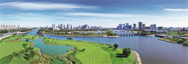
As deputy editor-in-chief of the newspaper Capital Construction, Ma has dedicated himself to documenting changes in Beijing, particularly those in the capital's subcenter of Tongzhou. The growing popularity of drone cameras in recent years has only made that job easier. "A bird's-eye view of the waterway is always more appealing," he says.
After the Grand Canal was listed as a UNESCO World Heritage Site in 2014, more parks mushroomed along its Beijing section in Tongzhou district. In the past three years, the local governments of Beijing and Hebei province have also worked to restore the 62-kilometer cruising route from Tongzhou to Langfang.
When the route redo was finally completed in June, Ma went to photograph tourists crossing the navigation lock on the border between Beijing and Langfang. "From above, you can see the beautiful river bend, the vast swathes of green along the banks, the improved air quality and the clear water below. Thanks to sustained antipollution campaigns, it is indeed a transformation," he says.


