HONG KONG - As winds from Typhoon Vicente battered Hong Kong, the Hong Kong Observatory raised Tropical Cyclone warning to the highest level of Hurricane Signal No. 10 at 00:45 local time on Tuesday (16:45 GMT on Monday).
Hurricane Signal No. 10 means that winds with mean speeds of 118 kilometers per hour or more are expected, the Observatory said in a statement.
 |
|
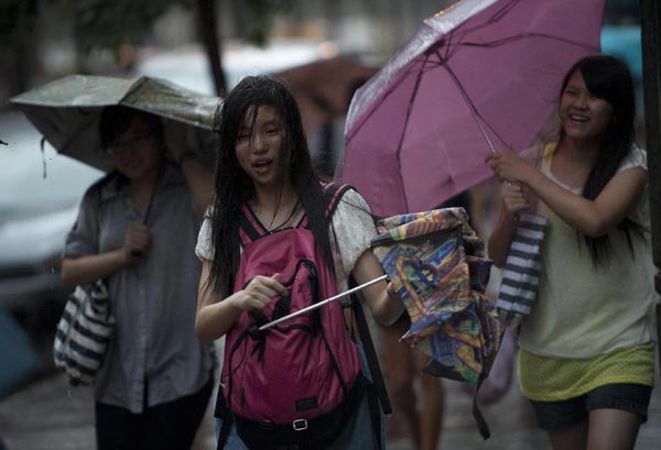
Citizens walk against the rainstorm in a street of Wanchai, south China's Hong Kong, July 23, 2012. Hong Kong Observatory forecasted typhoon "Vicente" would pass the area of about 150 kilometers southweat away from Hong Kong during Monday night and Tuesday morning. (Xinhua/Lui Siu Wai) |
At 01:00 local time, Severe Typhoon Vicente was centered about 100 kilometers southwest of the Hong Kong Observatory and is forecast to move to northwest at first at about 20 kilometers per hour towards the region to the west of the Pearl River Estuary. Vicente will move west-northwestwards later.
Vicente is expected to be closest to Hong Kong in the next few hours, passing within 100 kilometers of the Hong Kong Observatory. The eyewall of Vicente will come near to the southwestern part of Hong Kong, bringing hurricane force winds to those areas.
All Hong Kong residents are advised not to go outside, and remain where they are if protected and be prepared for destructive winds.
In the past hour, the maximum sustained winds recorded at Cheung Chau Beach, Tate's Cairn and Waglan Island were 127, 117 and 108 kilometers per hour respectively.
A high water level of about 3.0 meters above chart datum is expected at Quarry Bay between midnight and 03:00 local time. The high water level may cause flooding in low-lying areas in Hong Kong.
Hong Kong's tropical cyclone warning signals has five levels -- Standby Signal No. 1, Strong Wind Signal No. 3, Gale or Storm Signal No. 8, Gale or Storm Signal No. 9, and Hurricane Signal No. 10.
